🚜🌍 Harnessing GIS for Risk Management in Agriculture: A Game Changer for Crop Insurance 🌍🚜
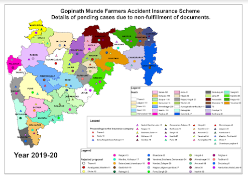
I'm excited to share some of the groundbreaking work we've been doing with GIS technology to revolutionize risk management in agriculture. By integrating geospatial data with field data, we've developed advanced tools that significantly enhance data visualization and decision-making for crop insurance. Here’s a glimpse into the benefits and results of our recent project:
Link for ppt presentation: https://docs.google.com/presentation/d/1koSaNoqYl-e8UttsnpHLIx2mXkDXjce5/edit?usp=sharing&ouid=103222577194977646189&rtpof=true&sd=true
Key Benefits:
- Crop Presence Detection: Efficiently identify and verify crop presence with GIS-based mapping.
- Precise Insured Crop Area Calculation: Accurately determine insured crop areas, particularly for orchards.
- Real-Time Analysis: Empower decision-makers with real-time visualizations of farmlands and associated data at the click of a button.
- Enhanced Data Visualization: Digital maps reveal spatial patterns and correlations that are often missed in traditional Excel reports.
Project Methodology:
- Integration of Village Cadastral Data: Attached with village names and census codes from boundary data.
- Crop Insurance Data Mapping: Joined with cadastral boundary data using GIS software, handling complex many-to-many joins.
- Horticulture Orchard Mapping: Combined with village parcel data using advanced geospatial tools.
Results:
- Improved Accuracy: Successfully aligned crop insurance data with cadastral boundaries and horticulture mapping data.
- Gap Identification: Detected discrepancies where insured crops were reported but not present on the ground.
This project underscores the transformative impact of GIS in agriculture, paving the way for more accurate, efficient, and insightful risk management solutions.


Comments
Post a Comment